Read about "Jolly Rancher" and "Kneecaps" on their 2009 Appalachian Trail thruhike from Georgia to Maine!
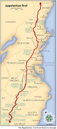
Welcome to my trail blog for my 2009 Appalachian Trail Hike! Here you can find all of my journal entries of my 2178.3 mile journey from Springer Mountain in Georgia to Mt. Katahdin in Maine. You can see my picture slideshow to the right, as well as a recap of my hike mile by mile and gear list. Download the ebook about my hike on iTunes. I hope you find my quest inspiring. Thanks for visiting and Happy Trails!
Thank you so much for following my great adventure on the Appalachian Trail. It truly was the trip of a lifetime and my proudest accomplishment. I finally climbed Mt Katahdin with my family on July 18th, 2009 as the 24th Northbound thru-hiker of the year.
I could not have done it without your support. I would especially like to thank those who have made a donation to the American Red Cross. Together, we have raised over $750 (including online and offline donations). I am very proud of the money that has been raised and I know that it will be put to good use right here in my hometown. Thank you again.
I hope you have enjoyed reading about my travels and perhaps it has inspired you to get out there and experience something new for yourself. Although my trail blog is officially complete, I hope to keep this website running for some time as a resource for others that are planning a thruhike of the AT or some other trail. In the coming weeks, I hope to upload some video reviews of the gear I used, as well as advice and answers to some of the questions that I have gotten along the way. Please check back soon for updates.
As for me, I am making the transition back to life here in the "real world." I am currently trying to juggle med school applications, family time, and the "honey do list" while allowing my body to recover from the five months of torture that it endured. My feet especially are in a great deal of pain and swelling. Nevertheless, I am happy to be home, reunited with my family and friends (and of course Harley).
Please feel free to contact me at harveysgwilliams@gmail.com if you have anything you want to ask about the trail or my journey. As an alumnus of the trail, I hope to be able to give back to the AT community, and one way I hope to do that is by helping the next generation of hikers by passing on what I have learned. Please feel free to contact me directly or pass my information on to anyone you know that may be planning a thruhike.
Once again, thank you for being a part of my journey. Happy Trails.
7/18/2009 - 9:00 PM - Appalachian Trail Lodge - 5.2 mi today - 2178.3 mi total
Woke up at 5 AM and got the daypacks ready for Katahdin. Had breakfast at the Appalachian Trail Cafe with Mom, Dad, and Rachel. The weather looked really nasty early with light rain and fog. Ate our fill and then made the drive to Baxter State Park. The ranger at the entrance station informed us that there was a 100% chance of rain and thunderstorms today. Got to the trailhead and began our hike at 8 AM. First mile flew by. Before we knew it we were at the Katahdin Stream Falls and took some pictures. The terrain wasn't bad to that point, though we were all getting wet quickly from the water falling off the trees. The higher we climbed, the more strenuous the terrain became. The boulders got larger and there was more scrambling higher up. Trekking poles quickly became useless, so we stored them on my backpack. Once we finally reached treeline, the terrain became ridiculous. We had a brief view looking West, but the fog thickened up quickly. Although the rain had stopped, the wind was picking up and the fog was thick. We reached the part known as "the wall" and had to use the rebar handholds to climb 12 feet vertically. We met some other thruhikers coming down at that point and they were making a big deal about it which frightened Mom. We all made it up that obstacle, then down a short slide, and then up over two more similar walls. Finally, we got to an obstacle that put Mom past her limit and forced her to turn around. Katahdin is a serious mountain and people get injured on it every week (last week a guy broke his ankle, and yesterday a woman broke her kneecap). I was proud of Mom for how far she came up the mountain, but I was more proud that she knew her limits and didn't put herself in a dangerous situation. She said a tearful goodbye, and headed back down the mountain to the parking lot. Dad, Rachel and I continued up the mountain and the conditions only got worse. The fog was very thick, the rocks were slippery, and the winds above treeline were gusting up to about 50 mph. We slowly made our way up and eventually saw a sign in the fog. I thought it was the famous Katahdin sign, but it wasn't. We had only reached the tableland, a relatively flat section of the climb, and still had a mile and a half to go. Frustrated, cold, wet, and worried about Mom, I hurried along towards the summit. We passed Thoreau Spring and I knew I was on the last mile of my hike. Finally, we could see the sign in the fog. I took the last few steps with Dad and Rachel and burst into tears. All that hard work. The ups and the downs. I was so happy to be there, but I was so sad for it to be ending. It was a whirlwind of emotions swirling inside of me. I collapsed on the sign and embraced it for a while. Dad and Rachel shot some pictures. I sat on top of it and took my summit photo. The fog was so thick that you can hardly recognize my face when you look at the photo. Took a couple pictures with Dad and Rachel. I did it.
At this point, we were all freezing and anxious to get back down off the mountain. After a short photo session and snack break, we turned around and started to head back. The descent was slow and the weather was much of the same. Luckily, the thunderstorms held off and we were not in danger. By the time we reached the bottom and were reunited with Mom, we were all exhausted, wet, cold, and sore. I signed my last logbook on the porch of the ranger station and found out that I was NOBO number 24. Woohoo. Hopped in the car and headed back to Millinocket for a shower, dinner, and some much needed rest. Great day on the AT, and what a way to end the hike. This is by far the best thing I have ever done in my life.
7/12/2009 10 PM – Long Pond Stream Lean-to – 15.1 mi today – 2078.8 mi total
Woke up to the smell of bacon. Good things happen on bacon days. AYCE breakfast was excellent. I had 6 eggs, bacon, and sausage, and 5 pancakes and home fries. Yum. Had to clear some space for it. Bought Aqua Mira and settled up. Hit the trail at 9. Took a picture at the 100-mile wilderness sign. Definitely not carrying 10 days of food. Very pretty walk. Sun was out and it was a beautiful day. Stopped for lunch at little Wilson falls. Really enjoying the 100-mile. Crossed Little and Big Wilson Streams. No problem there. Met Old Spice at Wilson Valley Lean-to. He started March 18. Nice guy. Cruised to Long Pond Stream Lean to and Splinter was there! Clean-shaven, it took me a second to figure it out. He finished June 26 and was coming back to do trail magic. He figured out where I was from my blog with some help from the people at Shaws. He had brought some beer up from his car, so we all drank and reminisced. He had some funny stories from katahdin. After 2 weeks off he wants to be back out here. Wonder what it will be like for me. Went to bed late, drunk, and happy!
7/13/2009 9 PM – Carl A Newhall Shelter – 20.8 miles today – 2099.6 mi total
Woke up at 6:30 and started to pack up. Rained overnight. Said thanks to Splinter as he headed to the car with all the empties and our trash. Hit the trail at 8 and took it slow. Spent a lot of time reflecting on my experience and getting misty eyed. Nice view from Burren Mountain. Couldn’t see Katahdin, though. Cruised along and enjoyed the scenery. 100 mile is very pretty, and we have been lucky with the weather. Stopped for lunch at 3rd Mtn, and just as we were leaving a huge rain shower hit. Had a little bit of hail too. Didn’t last long. Nice view from Chairback Mtn across to Whitecap. Pretty and easy descent to Pleasant River and an easy ford. Last 6 miles were gradual uphill and I was getting hungry. Shelter was full when we arrived, but EKG sweet-talked some SOBOs to give up their spots. EKG, Panama and I are inside with some section hikers. Old Spice had to tarp out. Felt bad for him. Hope it doesn’t rain. Thinking about big miles tomorrow. Only 2 more pages of guidebook left! End is near. Hoping for a good view of Big K from Whitecap!
7/14/2009 9 PM – Potaywadjo Spring Lean-to – 30.3 mi today – 2129.9 mi total
Woke up at 4:30. That was early. Got on the trail at 5. Wanted to get early start to push big miles. Had a snack at Sidney Tappon Campsite. Had Chariots of Fire stuck in my head. Thought about my XC days. 3 quick drinks and we were on top of White Cap looking out over a valley towards Katahdin. Summit was under clouds. Got a quick picture and moved on as wind was high. Snack break at Logan Brook Lean-to. My stomach was all messed up because I didn’t have my normal breakfast and was snacking all day. Cruised past East Branch Lean-to. Terrain was pretty easy today. Short uphill over Little Boardam Mtn. Afterwards it was super flat. I flew along to Cooper Brook falls lean-to and ate a massive breakfast/lunch. Met a SOBO who had injured herself and taken a month off. Hope to avoid the injury bug these last few days. Panama, EKG, and I flew the last 11 miles in 3.5 hours. Held a 3 mph pace for first time in a long time. Felt good to open up the stride again. Trail wasn’t too muddy, but there were a couple boggy spots. Got to the shelter at 6:30 with plenty of daylight. Bugs were bad so we lit a fire, though they are still buzzing around. Had a nice big dinner and enjoyed the company. Staying with a SOBO tonight. Planning another big day tomorrow, so we will be getting up early again, we’re definitely going out in style. Less than 50 miles to go. On the last page of the guidebook!
7/15/2009 9 PM – Abol Pines Campground – 33.2 mi today- 2163.1 mi total
Woke up at 4:30 again. Felt really stiff. Quietly made breakfast and swore a bunch. Popped 4 Vitamin I. Hit the trail at 5:15. Spring for the shelter was really cool. Water was bubbling out of the ground. Sun coming through the trees at a low angle was pretty. Had a nice view of Katahdin from Pemadumcoak Lake. Cloudy on top, but its getting closer. Trail was a bit muddier than yesterday, but not bad. It would have been really bad a week ago, but the recent nice weather had dried it out a bit. Saw some canoe campers across Namakanta Lake. That would be a fun way to see Maine. Rounded Wadleigh Stream Campsite at 9:15. Passed Panama pitter-pattering like a fat kid at a stream crossing. He was pissed when I just leapt across. Hilarious! Got some water and stuffed myself with snacks. Hit the trail again and had the last real climb before Katahdin. Nesuntabunt Mtn.Was very steep. Called home from the top. Started daydreaming on the downhill, which slowed me, down. Had to really focus to catch up to Panama and EKG. Got to Rainbow Stream Shelter at 1:15 and cooked a dinner for lunch. My legs were aching, but the hot food did wonders. Popped 4 more Ibuprofen, wrote in the shelter log and read some nostalgic entries from other NOBOs. Hit the trail again at 2. After 4 miles, I had Energy GU and Panama had 5-hour energy. Those things really work. Energy drinks and ibuprofen have really helped us on the last stretch through New England. Panama was flying and I did my best to keep up. Trail was pretty muddy and we had to dance from rock to rock. Managed to keep my feet pretty dry. Kept our head down and pounded out the miles. Beautiful view of Katahdin from Rainbow Ledges. Got to Hard Brook Lean-to just before 6. We could smell the finish line, but had to take a brake for sore legs.Saw a couple greenhorn SOBOs at the shelter. Absolutely crushed the last 3 miles and completed the 100 mile wilderness at 7. Took us 82 hours to walk 100 miles. Awesome! That makes today my longest 1-day, 2-day and 3-day stretch. What a bad ass way to finish. Got to the Golden Road at Abol Bridge and met Panama’s dad and brother. They fed us well and we demolished everything on the table. Recounted the day and basked in our success. After dinner, we went across the street to Abol Pines to claim our spots in the shelter. We were all thoroughly exhausted, but happy. Stayed up for a while reminiscing about all the good times at the trail. I’m really going to miss the trail when it’s over. Still living the dream and have 15 miles to go. Onwards!
7/16/2009 8 PM – Katahdin Stream Campground – 9.9 mi today – 2173.1 mi total
Woke up at 5:15 and was starving. Panama shared some trail mix and yogurt covered pretzels. After a while, I realized I wasn’t going tot fall back asleep, so I got up and wrote my journal and had breakfast. Abol Pines is a nice place. Right on the Penobscot River, it’s a peaceful place..until a logging truck blasts by. Took my time packing up and wandered over to the campground store. Ate ½ lb cheeseburger and 3 donuts. Hit the trail at 9 and the bugs were out. Signed in at the information kiosk and the BSP boarder. Didn’t stop long as the bugs were terrible. Took it easy and cruised all day long. Had two stream crossings. Managed to make it across the first one with dry feet, but not the second. Took a nice long break at Big Niagara Falls with Panama and reflected on the trip. Met his dad and brother-in-law near Daicey Pond and chatted for a while. Cruised into Katahdin Stream Campground around 1. Registered and chatted with the Ranger. The Birches were full with trail crew, so we got another lean-to. She also gave us some free firewood because we are cool NOBOs. Set up camp and got a fire going to keep away the mosquitoes. Sat around for a while until Blackgun showed up. He had just climbed Katahdin and was heading into town. He’s flip-flopping so he has to make his way to WV to finish (WV – GA) He lost his entire pack in one of the river crossings in the 100 mile wilderness because the water was so high. Yikes! We got pretty lucky with the water levels. Started to rain so I took a nap. When I woke up Panama’s dad and brother had brought us pizza, pasta, beer and McDonalds. Woo Hoo!! Stuffed ourselves thoroughly. Hung out for the rest of the evening. Great last night on the trail. Heading into town tomorrow to wait for Dad and Rachel. Only 5 miles left!
7/17/2009 6PM - Appalachian Trail Lodge - 0.0 mi today - 2173.1 mi total
Got up early and saw Panama and EKG off to the Hunt Trail. Enjoyed a fire over leftover breakfast pizza and then went to the road to hitch into town. Waited 2 hours for a ride. Bugs were bad. Finally arrived in Millinocket at 10:30. Went to the Appalachian Trail Cafe for breakfast number two. Charming place. Had some really funny AT illustrations on the wall from theartfulhiker.com that brought back many memories of the trail. Checked into the lodge and relaxed for a while. Caught up with my family as they were leaving Rochester and starting the long drive up here. Went to the library in the afternoon. There is a Harley Owners Group bike rally in town this weekend, so I saw the parade this afternoon. There were over 500 bikes. Pretty cool. Panama and EKG arrived around dinner time. Panama's family showered and then hopped in the car on their way to the coastline for the rest of the weekend. Sad to say goodbye. EKG and I went to the Cafe for dinner and another thruhiker, James, completed the Sundae Summit Challenge, which is 14 scoops of ice cream, snickers, M&M's, pie, chocolate sauce, and whipped cream. It was ridiculous. He looked in pain when he finished it. The biker guys were impressed. Afterwards, I retired to the Lodge and watched tv until my family arrived. Glad to see them. Looking forward to tomorrow. Hope the weather is good.
7/6/2009 - 9:00 PM - Gull Pond Lodge - 13.4 mi today - 1971.6 mi total
Woke up at 7:30 and was really sore from the marathon day yesterday. Took vitamin I and had breakfast. Lazy morning. Organized slackpacking with Bob at Orbeton Stream. Stopped by the post office on the way to the trail so I could pick up my mail drop. Glad that Bob knew where to go because the logging roads are very confusing. He's a typical Mainer. I asked him how to get to Poland Spring and he said "Ya cayn't get therr frum 'ere!" He always has a witty remark. My favorite part of this hostel is the picture of him leaning against the Katahdin sign with the back of his Chevy Suburban in the corner of the picture. He offered to take us up there and save us a whole heck of a lot of hiking. Recent rain had washed out part of the road, so we had to walk 40 minutes to get to the trailhead. Finally started real hiking at noon. Crossed Orbeton Stream without a hitch and started climbing. Stopped at Poplar Ridge Lean-to for lunch. Weather was looking really nice and sunny for a change. Was still feeling groggy on top of Saddleback Junior, so I had a 5-Hour Energy. Those things work! Flew up the next summit and waited for Panama Red and EKG to catch up. Beautiful views. Some locals pointed out Katahdin to us. Woohoo! First view of Big K. Could also see Mt Washington to the South. With the late afternoon sun came thunderstorms, so we got off the ridgeline quickly. Bypassed the Piazza Rock shelter and got back to Route 4 around 6:30. Hitched into town and must have passed Bob going the other direction. Met up with him in the IGA parking lot. Went back to the hostel and cooked dinner. Watched some Deadliest Catch and went to bed around 11 after a shower. Good recovery day. More slack-packing tomorrow!
7/7/2009 - 10:00 PM - Stratton Motel - 18.8 mi today - 1990.4 mi total
Got up at 6:30 today and was in the truck at 7. Wanted to get an early start to get to Stratton. Had to walk 40 minutes to the trailhead again, so didn't get started until about 8:30. Big climb up Lone Mountain. Stopped at Spaulding Mountain Lean-to in the fog for lunch. Wet and cold day. Good day to slackpack. Went up and over Spaulding Mountain and bypassed the Sugarloaf side trail as there was no hope for a view today. Steep downhill to the Carrabassett River. Were able to get across without getting our feet wet. Big climb up and over Crocker Mountain (2000 up and down). Panama took a 5 hour energy and left me in the dust. He got to the road 20 minutes before EKG and I and was standing there shivering from the cold rain. Hitched a ride into Stratton around 6:30. Got our spots at the Stratton Motel and went to the White Wolf Inn for Wolfburgers (halfpound cheeseburgers with bacon and sausage). Yum. Got a pint of Ben & Jerry's from the general store for desert. Came back to the motel and took a shower. Watched TV and crashed on the couch. It will do me good to get away from TV for a while...
7/8/2009 - 10:00 PM - Sratton Motel - 16.7 mi today - 2007.1 mi total
Woke up at 6:30 and had breakfast. Suzie took us to the trailhead at East Flagstaff Road, so we could slackpack back to Stratton today. This is our 5th day of slackpacking, but it has been really good because it allowed us to get through the mountains of Southern Maine while saving our legs. Its a battle every morning just to get out of bed. Ibuprofen and energy drinks are a necessity. Hit the trail at 8 in the fog and wet. Climbed over Little Bigelow quickly. Found a dry spot under a huge boulder to have an early lunch. Big climb up Bigelow. No views at all from the top as the weather was crappy. Stopped by Horns Pond Lean-to for a snack break and talked to the caretaker. We think we are somewhere around number 20 for NOBO's. Woohoo. Very easy hike from there to the road. Finished by 5 PM. Hitched into town and ordered pizza from the General Store. Bought some beer to celebrate crossing the 2000 mile mark. Also planning to complete the "12 pack challenge" tomorrow on Panama's birthday. Should be fun. No more slacking, but we are now back on schedule for summiting on the 18th. Mixed emotions as I get towards the finish line. One day at a time.
7/9/2009 - 8:30 PM - Pierce Pond Lean-to - 15.9 mi today - 2023.0 mi total
Woke up at 6:30 and wished Panama happy birthday. Had my granola, but decided to get 2nd breakfast at the Stratton Diner. Waitress was a sweet old lady. Had an omelette. Settled up with Suzie at the motel and hopped in the car with my full backpack plus a 12 pack. That felt super heavy after 5 days of slackpacking. Had our first beer at the trailhead and the next soon thereafter. Took pictures at the 2000 mile sign (it's actually at mile 2009 on Long Falls Dam Road). Cruised to West Carry Pond Lean-to for lunch and met a couple SOBOs and ate by the pond. Beautiful day and the water was flat. Had beers 6 and 7 and stumbled down the trail. Really flat hiking in the afternoon. Mix of bog bridges and rock hopping. Got to Pierce Pond at 6 and completed the challenge. Beautiful place. Washed my shoes and socks and went for a swim with the leeches (very short swim). Pumped water and cooked dinner. Drying my shoes out with newspaper. Can hear the loons on the pond. Bugs are bad tonight. 155 miles to go.
7/10/2009 - 9:00 PM - Moxie Bald Shelter - 22.8 mi today - 2045.8 mi total
Woke up at 6:30 to a beautiful view of Pierce Pond. Saw 2 loons swimming. Dry shoes didn't last long. Coasted downhill to the Kennebec River by 9. Beautiful day with no clouds in sight. The ATC provides a ferry across the river because it is so big and there is a dam upriver that releases on an irregular schedule. Dave paddled over in his canoe and loaded our packs. Signed a release form and then made our way across. Current was pretty strong (8mph). Panama sat in the middle and took pictures, so I had to go up front and paddle. Haven't had an arm workout in months. Stopped by the Post Office in Caratunk and shipped home 7 pounds of gear (Panama shipped 4 lbs). I am litterally carrying only what I need to survive now. Hopefully this will allow us to sprint to the finish. Mom will probably flip when she opens the box. Feels like I am slackpacking again... almost. As we were leaving town, a lady offered us a beer each. Gotta love trail magic. Tough hiking without my poles. Used a leafy stick for a while but got tired of it. Lunch at Pleasant Pond Lean-to where SOBOs had written about the 2 mountains north of there as if they were Everest. They were really just little 1000 foot bumps. They have a lot to learn. Steamed over Pleasant Pond Mountain and took a short break at Bald Mountain Brook Leanto. View from Moxie Bald was was spectacular. First good view of Katahdin. The end is near! Stopped for the night at moxie Bald Leanto. Bugs are bad tonight. Time to slap on some DEET and hit the sack.
7/11/2009 - 10:00 PM - Shaw's Lodging - 17.9 mi today - 2063.7 mi total
Woke up at 7 and was sore from yesterday. Got moving slowly and was on trail at 8. Easy to pack the bag when you don't have much. Another beautiful day. Wonder how long this nice weather will last. Really flat day. Fording the West Branch of the Piscataquis was a little sketchy. Had to get a leafy stick. Lunch at Horseshoe Canyon Leanto and met some SOBO's. EKG lost her camera sometime in the morning. Bummer. Cruised along in the afternoon. East Branch of the Piscataquis was much lower. Easy crossing. Reached Monson by 3:30. We were really cruising! Got my mail, including my new shoes (pair number 4). Good thing because I blew holes in the side of my old pair. I look like a total newbie with my shiny new shoes and fresh socks. Called home and then went to the local BBQ joint. Had a plate and then hit the gas station for a hiker sized calzone. Panama sweettalked the girl behind the counter and she threw some bacon in the calzone for free. Had a beer to celebrate the last town on the trail. Only 114 to go. Came back to the hostel to hang out. Think it will storm tonight. Glad to be inside. Met some SOBO's. The beards get shorter the farther North we go. Enter the 100 Mile Wilderness tomorrow. Woohoo. One week to go!
7/1/2009 9:00 PM - Carlo Col Shelter – 16.9 mi today – 1897.3 mi total
Woke up at 7 to find the SoBos gone. Make breakfast, caught the weather forecast (crappy for a week), and packed up. Got dropped off at the trail at 9. Met four more SoBos. They are all bunched up right now. Androscoggin River is really high right now. Eased into the day’s warm and humid intermittent rain. The news said this was the second wettest June on record. Shoes were wet quickly. Trudged through the mud all day. Snack break at Tridet Col Tent site. Lunch at Getain Pond. Climbed Mt. Success, which was very anti-climactic (no sign at top!) Trudged through some more with soaking wet feet. Finally at 7:30, we crossed into Maine, great feeling! Took some pics and celebrated with Panama. Officially a GA-ME hiker. Got to the shelter shortly thereafter and met 3 section hikers. Cooked dinner, pumped water, and now to bed. Psyched for Mahoosuc Notch tomorrow! Only 281 miles to go and 17 more days!
7/2/2009 8 PM – Speck Pond Shelter – 9.5 mi today – 1906.8 mi total
Woke up at 7 and hit the trail at 8:15. SPOT is playing me up and won’t send OK messages, only tracking. Very frustrating. Cloudy, wet, windy, and cold today (again). First four miles were some of the worst of my entire trip. Had lunch at Full Goose Shelter and felt down and out. Read the shelter log and it sounded like a lot of other NoBos felt the same way. Panama and I stuffed ourselves and hit the trail. Mahoosuc Notch was awesome. Very narrow canyon with huge boulders that you have to climb over and around. There were some really tight spots, but we kept our packs on the entire time. Took about 2 hours to go one mile. Huge climb out to Specks Pond. We were in a pond so everything is damp. Getting to bed early and will sleep hard tonight. When will this rain end?
7/3/2009 9 PM – The Cabin – 14.9 mi today – 1921.7 mi total
Woke up at 7 feeling groggy. Slept pretty hard last night. Got on the trail at 8:15. Thick fog and wet trail to start out. Climbed up and over Speck Mtn. Descended to Grafton Notch where the sun finally broke through the clouds for the first time in 3 days. Didn’t last long. With this much moisture in the air, sunlight leads to heat lends to atmospheric destabilization leads to T-storms. Happens like clockwork. Ate lunch at Baldpate lean to 2 miles down the road and the T-storms rolled in. Moved on during a break in the storm. Climbed Baldpate Mtn.And got our first view in Maine. It was beautiful, but I knew it meant more rain to come. Called the Cabin to set up a pick-up. Pumped some water in Frye Notch lean to and climbed over Surplus Mtn. It poured on us. Every day I get more wet than I was the day before! Dunn Falls were flowing fast and hard so we took the blue blaze around. One false step would have been perilous. Met Earle at East B Hill Road and he had towels for Panama and I. Stopped in at the store in Andover and got some milk and cookies. Got to the cabin and downed all the beef stew we could have. Ate ice cream afterwards. Went to bed happy, warm, dry, and full. Looking forward to slack packing tomorrow.
7/4/2009 9:15 PM – The Cabin – 10.1 mi today – 1931.8 mi total
Woke up at 6 to an enormous breakfast. Cook our own omelets, blueberry pancakes, biscuits, gravy and of course bacon. Took some of the leftovers for an afternoon snack. Yum. Packed up the daypacks and hit the trail at 8. The trail was wet and muddy all day long (no surprise there!). We were cruising early, but got our directions mixed up and ended up walking the wrong way down a dirt road. Probably walked an extra 2 miles, very frustrating, especially when it started to rain. Its tough to keep your head up when you are cold and wet and homesick. In tough times you have to take it a day, a mile, and sometimes even one step at a time and just refocus yourself. To be out here is a blessing, but in tough times it is hard to see that. Trudged along behind Panama to Hall Mtn Lean-to. Had our snacks and talked with White Hat and ½ measure who were also slack packing today. From there it was 1500 ft down to Sawyer Notch, fording Sawyer Brook, 1500 feet up over Moody Mtn, and 1000 ft down to ford Black Brook, which was at waist height. Passed a couple that were rock hopping around the puddles and looked embarrassed as we plowed through the water. Met Earle at the road next to the Black Brook and decided to call it a day as it was already 2. Got back to the cabin and did some logistics. Planed my next week, but all is likely to change. Dinner was excellent. Cheeseburger for the 4th. Here with EKG and 180 tonight. Big day tomorrow, so time for bed. SPOT is broken L Hoping for sun tomorrow.
7/5/2009 11 PM –Gull Pond Lodge – 26.4 mi today – 1958.2 mi total
Woke up at 6 and had another enormous breakfast. Packed up a couple of biscuits for the trail. Bid farewell to Maggie, Mollie and Earle and hit the trail at 8. Started with a big climb up Old Blue Mtn. Cold and windy at the top so I didn’t stay long. Trail was muddy as usual, but there were some spots that appear to be drying out a bit. Slack packing felt great and we were finally able to open our stride and crank out the miles. Stopped for lunch at Bemis Mtn Shelter. Slick descent from Bemis to the stream where we had to ford, but water was surprisingly slow. Next 13 miles were gently rolling. Had some nice views along a couple small ponds. Called Bob at Gull Pond Lodge and arranged our pick-up at 8. Drove to Rangeley and saw a beautiful sunset over Rangeley Lake. Hope this nice weather sticks around. Stopped by IGA to pick up some dinner (rotisserie chicken) and lunch for tomorrow (big sub). Got to the Gull Pond Lodge after dark. Ate, showered, and now to bed. Good day on the trail. Only one more town to stop after this one. Countdown is on!
Yesterday (July 18th) I finally climbed Mt Katahdin and completed my thruhike. Woooohoooo! Thanks everyone for your support the whole way. Today we are driving home, a 12 hour ride, but I will fully update my blog in the coming days. Happy Trails!
Hi all! Sorry for the delay in uploading my blog. I am in Stratton, ME with 187 miles left to go. I'm still hanging with Panama Red and we have picked up a new friend in EKG. The past five days, we have slackpacked from Andover to here and we will be slacking again on Wednesday as well (surpassing the 2000 mile mark and getting up and over Bigelow Mountain). Once we clear that hurtle, it's fairly smooth sailing to Katahdin (in terms of elevation gain/loss... miles are still miles). We are shooting to finish on July 18, so we need to average about 18 miles a day, which is definitely doable. Unfortunately, my SPOT has broken, so you won't be able to watch me climb Katahdin, but I promise to post all of the journal entries, photos, videos, and a bunch of other stuff after July 18th. I won't have time to upload much between here and there. The weather has been wet (no surprise there), but we are keeping our fingers crossed for sunny skies as we near Katahdin. We got our first glimpse of her from the top of Saddleback on Monday, though she was really far away. So that's the news. I sent my full journal home and got a fresh one a couple days ago, so look for the July 1-5 entries soon. Thanks to everyone for your support. I really needed it through the crappy New England weather. On to Katahdin!
Thank you to everyone who contributed to the Red Cross in support of my hike. Together, we raised over $1200!
Photos
by HarleyandMe
Click the picture to view all the pictures from my trip. You can also see my slideshow by clicking here.
About The Hike:
Click here to see how far I hiked everyday. I averaged about 16 miles per day. My days ranged in length from 4 to 33 miles.
Check out my pictures! You can see my slideshow on Youtube in three parts. Part 1. Part 2. Part 3. I also filmed 15 seconds in each state. You can see that here. Also, here is a link to my Youtube channel which has all of the videos from the trail.